
Byron, California
This article's lead section may be too short to adequately summarize the key points. (November 2024) |
Byron | |
|---|---|
 Byron sign | |
 Location in Contra Costa County and the state of California | |
 Byron Location in the United States | |
| Coordinates: 37°52′02″N 121°38′17″W / 37.86722°N 121.63806°W | |
| Country | |
| State | |
| County | Contra Costa |
| Government | |
| • State senator | Jesse Arreguín (D)[1] |
| • Assemblymember | Lori Wilson (D)[2] |
| • U. S. rep. | Josh Harder (D)[3] |
| Area | |
• Total | 6.52 sq mi (16.89 km2) |
| • Land | 6.52 sq mi (16.89 km2) |
| • Water | 0.00 sq mi (0.00 km2) 0% |
| Elevation | 33 ft (10 m) |
| Population (2020) | |
• Total | 1,140 |
| • Density | 174.82/sq mi (67.50/km2) |
| Time zone | UTC-8 (Pacific) |
| • Summer (DST) | UTC-7 (PDT) |
| ZIP code | 94514 |
| Area code | 925 |
| FIPS code | 06-09346 |
| GNIS feature IDs | 238290, 2407934 |
Byron is a census designated place (CDP)[6] in Contra Costa County, California, United States.
History
[edit]Byron's location was part of a land grant that Jose Noriega received from the King of Spain in 1835. Noriega then sold 17,000 acres to John Marsh for the equivalent of $500 (three U.S. cents per acre). In 1841, the Bidwell-Bartelson wagon train arrived at Marsh's ranch with the earliest Anglo settlers from the east.[7]
Byron's first post office opened in 1878.[8] Byron is named after an employee of the San Pablo, and the eastern U. S. and Pacific Railroad.[a]
In 1942, all of the town's residents of Japanese descent were forcibly removed by the US government with pressure from California agricultural interests and taken to Turlock assembly center.[9][10]
In 1960, Contra Costa County built the Orin Allen Youth Rehabilitation Center, better known informally as the Boys' Ranch on a 50 acres (200,000 m2) tract immediately southeast of Byron. The Boys' Ranch is a minimum-security facility that houses up to 100 youthful offenders. The property has no security fence to contain residents within the perimeter and includes dormitories, classrooms, a kitchen and dining facility, athletic facilities and administrative offices which occupy about one-third of the area. Its objective was stated as rehabilitation, rather than simply detention.[11]
In 2008, a Contra Costa County Grand Jury began an investigation into whether the facility was cost-effective, or whether it should be permanently closed. It began by conducting an unannounced site inspection in September, 2008. In 2009, it released its report to the county commissioners. The report identified 21 defects at the facility that needed correction.[11]
Geography
[edit]According to the United States Census Bureau, the CDP has a total area of 6.5 square miles (17 km2), all of it land. It is located 5.5 miles (9 km) southeast of Brentwood.[8]
Climate
[edit]This region experiences hot and dry summers, with average monthly high temperatures varying from 55 degrees in January to 93 degrees in July. Byron is windy, and dust devils sometimes appear. According to the Köppen Climate Classification system, Byron has a warm-summer Mediterranean climate, abbreviated "Csb" on climate maps.[12]
Gallery
[edit]-
 The San Francisco Call reporting the Byron Train Disaster, December 1902
 -
 Families of Japanese ancestry being removed from Byron during World War II
 -
 Main Street, Byron, California 2008


Demographics
[edit]| Census | Pop. | Note | %± |
|---|---|---|---|
| 2010 | 1,277 | — | |
| 2020 | 1,140 | −10.7% | |
| U.S. Decennial Census[13] 1850–1870[14][15] 1880-1890[16] 1900[17] 1910[18] 1920[19] 1930[20] 1940[21] 1950[22] 1960[23] 1970[24] 1980[25] 1990[26] 2000[27] 2010[28] | |||
The 2020 United States census reported that Byron had a population of 1,140. The population density was 174.8 inhabitants per square mile (67.5/km2). The racial makeup of Byron was 51.6% White, 2.3% African American, 1.9% Native American, 0.4% Asian, 0.3% Pacific Islander, 27.4% from other races, and 16.1% from two or more races. Hispanic or Latino of any race were 50.5% of the population.
The Census reported that 98.5% of the population lived in households, no one lived in non-institutionalized group quarters, and 1.5% were institutionalized.
There were 374 households, out of which 34.2% included children under the age of 18, 55.6% were married-couple households, 5.6% were cohabiting couple households, 21.1% had a female householder with no partner present, and 17.6% had a male householder with no partner present. 17.9% of households were one person, and 7.2% were one person aged 65 or older. The average household size was 3.0. There were 285 families (76.2% of all households).
The age distribution was 22.9% under the age of 18, 8.7% aged 18 to 24, 24.2% aged 25 to 44, 29.6% aged 45 to 64, and 14.6% who were 65 years of age or older. The median age was 39.4 years. For every 100 females, there were 110.7 males.
There were 377 housing units at an average density of 57.8 units per square mile (22.3 units/km2), of which 374 (99.2%) were occupied. Of these, 66.6% were owner-occupied, and 33.4% were occupied by renters.[29][30]
Education
[edit]Byron is in the Byron Union School District and the Liberty Union High School District.[31]
Former resort
[edit]37°50′54″N 121°38′00″W / 37.84833°N 121.63333°W
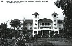
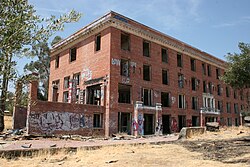
Byron, California is also home to the somewhat well-known and historical Byron Hot Springs, a now-abandoned resort that was a retreat that attracted many movie stars and famous athletes in the early 1900s. The first hotel was built around 57 hot springs and owned by Lewis Mead in 1889.[32] The hotel included a three-story wood building, with a few cottages scattered nearby, as well as a laundry, gas plant and ice plant, all of which were destroyed by fire on July 25, 1901. A second hotel, also three stories, but made of stucco was constructed 1901–1902, but it burned on July 18, 1912. The third and final hotel, a four-story brick structure was built in 1913, reopened in 1914.[33]
In 1938 the resort closed, after a series of lawsuits that were probably brought about by the Great Depression, but was leased by the government in 1941 and became a military interrogation camp housing both German and Japanese prisoners of war, known as Camp Tracy, until 1945, when orders were sent to dismantle it.[34]
In 1947 Byron Hot Springs was put up for sale and purchased by the Greek Orthodox Church for $105,000. It served as Monastery St. Paul for several years. It then changed hands several times as a resort, country club, and private residence. In 2008, a developer announced plans to restore the resort.[35] As of 2021[update] a Byron Hot Springs website retains a "Resort Plans" page for the restoration of Byron Hot Springs.[36]
In 2005, a Victorian-era carriage house on the property was burned to the ground. The hotel itself sustained some fire damage, but still stands.[37]
Byron Hot Springs is 1.5 miles (2.4 km) south-southeast of Byron.[8] A post office operated at Byron Hot Springs from 1889 to 1930.[8]
- Byron Hot Springs
-
 Second Byron Hot Springs Hotel, 1901–1912
 -
 Byron Hot Springs, 1908
 -
 Postcard, Byron Hot Springs, 1914
 -
 Postcard Byron Hot Springs, 1923
 -
 Byron Hot Springs, 2008


Transportation
[edit]Byron Airport
[edit]In 1993 Contra Costa County broke ground on a new airport two miles (3 km) south of Byron. On October 8, 1994, Byron Airport was dedicated. The new airport has 1,307 acres (5.29 km2) of land. 814 acres (3.29 km2) are reserved for habitat management land for the San Joaquin kit fox, a federally listed endangered species, as well as many other endangered and special status species.
This is the home airport of the Patriots Jet Team.[38] It has also been used for illegal drag races in the past.
Notes
[edit]- ^ Later acquired by the Southern Pacific Railroad[7][8]
References
[edit]- ^ "Senators". State of California. Retrieved March 28, 2013.
- ^ "Members Assembly". State of California. Retrieved March 28, 2013.
- ^ "California's 9th Congressional District - Representatives & District Map". Civic Impulse, LLC. Retrieved March 9, 2013.
- ^ "2020 U.S. Gazetteer Files". United States Census Bureau. Retrieved October 30, 2021.
- ^ "Byron". Geographic Names Information System. United States Geological Survey, United States Department of the Interior. Retrieved October 20, 2014.
- ^ "Byron CDP, California - Housing, Employment, Education, More". www.homearea.com. Retrieved December 3, 2019.
- ^ a b East Contra Costa Historical Society
- ^ a b c d e Durham, David L. (1998). California's Geographic Names: A Gazetteer of Historic and Modern Names of the State. Clovis, California: Word Dancer Press. p. 609. ISBN 1-884995-14-4.
- ^ Department of the Interior. War Relocation Authority (April 28, 1942). Byron, California. These field laborers of Japanese ancestry at Wartime Civil Control Administration . . . Series: Central Photographic File of the War Relocation Authority, 1941 - 1989 – via US National Archives Research Catalog.
- ^ Department of the Interior. War Relocation Authority (May 2, 1942). Byron, California. Main Street of small town in the farming district, on morning of evacuation. Si . . . Series: Central Photographic File of the War Relocation Authority, 1941 - 1989 – via US National Archives Research Catalog.
- ^ a b IT’S TIME TO PULL THE PLUG. Contra Costa County 2008-2009 Grand Jury Report No 0905. Accessed March 17, 2018.
- ^ "Byron, California Köppen Climate Classification (Weatherbase)". Weatherbase.
- ^ "Decennial Census by Decade". United States Census Bureau.
- ^ "1870 Census of Population - Population of Civil Divisions less than Counties - California - Almeda County to Sutter County" (PDF). United States Census Bureau.
- ^ "1870 Census of Population - Population of Civil Divisions less than Counties - California - Tehama County to Yuba County" (PDF). United States Census Bureau.
- ^ "1890 Census of Population - Population of California by Minor Civil Divisions" (PDF). United States Census Bureau.
- ^ "1900 Census of Population - Population of California by Counties and Minor Civil Divisions" (PDF). United States Census Bureau.
- ^ "1910 Census of Population - Supplement for California" (PDF). United States Census Bureau.
- ^ "1920 Census of Population - Number of Inhabitants - California" (PDF). United States Census Bureau.
- ^ "1930 Census of Population - Number and Distribution of Inhabitants - California" (PDF). United States Census Bureau.
- ^ "1940 Census of Population - Number of Inhabitants - California" (PDF). United States Census Bureau.
- ^ "1950 Census of Population - Number of Inhabitants - California" (PDF). United States Census Bureau.
- ^ "1960 Census of Population - General population Characteristics - California" (PDF). United States Census Bureau.
- ^ "1970 Census of Population - Number of Inhabitants - California" (PDF). United States Census Bureau.
- ^ "1980 Census of Population - Number of Inhabitants - California" (PDF). United States Census Bureau.
- ^ "1990 Census of Population - Population and Housing Unit Counts - California" (PDF). United States Census Bureau.
- ^ "2000 Census of Population - Population and Housing Unit Counts - California" (PDF). United States Census Bureau.
- ^ "2010 Census of Population - Population and Housing Unit Counts - California" (PDF). United States Census Bureau.
- ^ "Byron CDP, California; DP1: Profile of General Population and Housing Characteristics - 2020 Census of Population and Housing". US Census Bureau. Retrieved March 26, 2025.
- ^ "Byron CDP, California; P16: Household Type - 2020 Census of Population and Housing". US Census Bureau. Retrieved March 26, 2025.
- ^ 2020 CENSUS - SCHOOL DISTRICT REFERENCE MAP: Contra Costa County, CA (PDF) (Map). Suitland, Maryland: U.S. Census Bureau. Retrieved January 24, 2025. - Text list
- ^ Pereira, Alyssa. "Wild history of East Bay 'haunted' landmark: Parties, a train crash, and hot springs interrogations." March 19, 2018.
- ^ "Byron Hot Springs Resort.", lostamerica.com
- ^ Corbin, Alexander D (2009). The History of Camp Tracy: Japanese WWII POWs and the Future of Strategic Interrogation. Ft Belvoir: Ziedon Press. ISBN 9780578029795. Retrieved August 21, 2021.
- ^ Fagin, Kevin (November 9, 2008). "Developer has grand plan for crumbling resort". San Francisco Chronicle. Retrieved August 21, 2021.
- ^ "Resort Plans". Byron Hot Springs. Retrieved August 21, 2021.
- ^ Jensen, Carol A. (2006). Images of America: Byron Hot Springs. San Francisco: Arcadia Publishing. p. 128. ISBN 0-7385-4700-X.
- ^ History of Contra Costa County Airports Archived August 20, 2008, at the Wayback Machine. Retrieved 2007-08-14.
External links
[edit]![]() Media related to Byron, California at Wikimedia Commons
Media related to Byron, California at Wikimedia Commons
- Byron Hot Springs 37°50′54″N 121°38′00″W / 37.84821°N 121.633241°W
- Reclamation District 800
- Byron Hot Springs
| Bodies of water |
|  | |||||||||||
|---|---|---|---|---|---|---|---|---|---|---|---|---|---|
| Counties | |||||||||||||
| Cities and towns |
| ||||||||||||
| CDPs over 10k | |||||||||||||
| Sub-regions | |||||||||||||
| Other | |||||||||||||
